Centers of Civilization
Introduction
Lorem ipsum dolor sit amet, consectetuer adipiscing elit. Donec molestie.
Sed aliquam sem ut arcu. Phasellus sollicitudin. Vestibulum condimentum facilisis
nulla. In hac habitasse platea dictumst. Nulla nonummy. Cras quis libero.
Cras venenatis. Aliquam posuere lobortis pede. Nullam fringilla urna id leo.
Praesent aliquet pretium erat. Praesent non odio. Pellentesque a magna a
mauris vulputate lacinia. Aenean viverra. Class aptent taciti sociosqu ad
litora torquent per conubia nostra, per inceptos hymenaeos. Aliquam lacus.
Mauris magna eros, semper a, tempor et, rutrum et, tortor.
Cordoba
The city of Córdoba is located on the north bank of the Guadalquivir
River in the southern region of Spain known today as Andalusia.
Though the city is perhaps best known as the capital of a branch of
the Umayyad dynasty that ruled the Iberian Peninsula from the middle
of the eighth-century until the early eleventh-century, Córdoba
was heir to a distinguished history before the advent of Islamic rule
in the region. Originally a Phoenician city, Córdoba was conquered
for Rome in 152 BC and eventually became the capital of the Roman province
of Hispania Ulterior. In the sixth-century the city was conquered by
Visigothic forces, and in 711 by a combined Arab and Berber army. This
last conquest paved the way for Abd al-Rahman I, an Umayyad prince from
Syria, to establish himself as an independent ruler on the Iberian Peninsula.
During the period of Umayyad rule, which ended in 1035, the city's
Roman walls and famous bridge were repaired, hydrological infrastructure
appropriated and expanded, an impressive number of urban foundations
were constructed in the city, and numerous suburbs developed around the
original walled Roman/Visigothic city (madina). The rectangular madina
was divided into four quarters by the intersection of the Roman cardo
and decumanus, forming two major arteries from which others branched
and around which development occurred. The decumanus was the main north-south
thoroughfare, terminating at the southern end of the madina. This southern
section was the city's most important civic space, distinguished by a
concentration of government, religious, and commercial institutions.
Here travelers entered the city from the rebuilt Roman bridge and would
have emerged into an open space from which the city's principal thoroughfares
opened, and which was bordered by government buildings to the northwest,
including the palace of the Umayyad rulers (no longer extant). Córdoba's
most famous monument, the Great Mosque, is located in this section of
the city, where it was once connected to the Umayyad palace with a covered
passage over the street (sabat).
Founded by Abd al-Rahman I, the Great Mosque was considered a wonder
of the medieval world and was appropriated as the cathedral of Córdoba
when the Christian forces of the Castilian crown conquered the city in
1236. The most important thoroughfare, al-Rasif, stretched along the
river in this southern section of the medina, and was used for public
processions. This section of Córdoba boasted a concentration of
markets, including the royal market for luxury goods known as al-Qayseriyya,
as well as taverns, caravanserais, baths, and inns that catered to the
merchants and other travelers that flocked to this cultural capital of
the western Mediterranean. Although it is difficult to verify the accounts
of the medieval geographers, poets, and authors who wrote admiringly
of the city's thousands of mosques, shops, baths, and palaces, Córdoba
was perhaps the most important cultural center of the medieval western
Mediterranean.
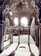
Abd al-Rahman III began construction of Madinat al-Zahra, a planned
palatine city 4 kilometers west of Córdoba, that further stimulated
development of suburban and country estates in the western zone.
Constructed on a series of rectangular terraces at the foot of the
Sierra Morena mountain range, Madinat al-Zahra boasted its own markets,
mosques, and population that served the caliph, his administrators, and
the army who relocated to the new city from old Córdoba. Madinat
al-Zahra was sacked and destroyed in the early eleventh-century, a tumultuous
period in Cordoba's history. Excavations ongoing since the early twentieth-century
in the official and residential areas of the upper two terraces have
revealed a fraction of the palatine city. Its former luxury are reflected
in the reception halls, residential quarters, gardens and pavilions located
on the city's upper two terraces.
Fatehpur Sikri
Fatehpur Sikri derives its name from the village of Sikri which occupied
the spot before, the prefix Fatehpur, City of Victory, was added in 1573
after Akbar's conquest of Gujerat in that year. Akbar chose this site
for a city out of reverence for Sheikh Salim, a religious mystic of the
Chisti order who prophesied that he would have three sons. In order to
ensure the efficacy of the prophecy Akbar moved his pregnant wife to
Sikri where she had two sons. In response Akbar decided to build an imperial
mosque and palace at the village of Sikri. The location of the palace
and mosque at the site encouraged further settlement by courtiers, noblemen
and their attendants so that within a few years a city had grown up which
was enclosed by a defensive wall. The city is built on the ridge of a
hill next to a lake which has now dried up, giving rise to the theory
that the city was abandoned because its water supply had failed. The
centre of the city was the palace and mosque, which are located on the
top of the ridge overlooking the lake, while the rest of the city was
located on the sides of the ridge away from the lake. The city occupies
an area of 5 km square with a wall on three sides and a fourth side open
to the lake. There are three main gateways in the city wall between which
there are semi-circular buttress towers.
The rise of the city from 1571 was very rapid so that after 1573 it
was regarded as the capital of the Mughal Empire. However, after the
city was abandoned by Akbar in 1585 to fight a campaign in the Punjab,
the city seems to have declined just as rapidly so that by 1610 it was
completely abandoned. The reason for the sudden decline of the city is
usually given as the failure of the water supply, however the real reason
may have been the emperor's loss of interest in the place. As the sole
reason for the city's existence seems to have been a whim of the emperor,
the fact that he was no longer in residence meant that there was no longer
any incentive for anybody else to stay. The effect of the emperor's presence
on the place may be gauged from an early description of the town which
described the road from Agra to Fatehpur Sikri as completely filled with
merchants' shops and stalls as if the two cities were one. A useful analogy
may be with the Abbasid capital of Samarra which flourished for fifty
years until the caliphs moved back to Baghdad when it declined to the
level of a market town.
The first major structure built at the site was Jami Masjid (congregational
mosque) which was completed in 1571 the year of Sheikh Salim's death.
At the time of its construction it was the biggest mosque in India measuring
160 m east-west by 130 m north-south. The central courtyard is surrounded
by arcades of pointed arches which lead into small cell-like rooms. The
centre of the west of the courtyard is dominated by the sanctuary which
has a huge central iwan leading on to a domed area in front of the main
mihrab. Either side of the central dome are two smaller domes each covering
the area in front of a smaller mihrab. As elsewhere at Fatehpur Sikri
the building is covered with Hindu architectural features, thus the arcade
of the sanctuary and the central iwan are capped by lines of chatris
and internally the roofs are supported on Hindu-style carved columns,
whilst the domes are supported on corbels in the tradition of Indian
temple architecture. Approximately in the centre of the north side of
the courtyard are two tombs, one belonging to Sheikh Salim and another
to his grandson Islam Khan. The tomb of Sheikh Salim consists of a square
domed chamber with an outer veranda filled in with a pierced marble screen
(jali). The outside of the tomb is protected by a sloping canopy (chajja)
supported on snake-like brackets. There are two main entrances to the
mosque, a small private entrance from the palace on the east side and
a monumental public entrance on the south side. The public entrance is
known as the Buland Darwaza and was built in 1576 to commemorate Akbar's
victory over Gujarat. The gate's name Buland Darwaza, Â'Tall Gate',
refers to the gate's outstanding height of 40 m. Like most Mughal mosques
this building is raised up on a terrace so that the entrances are approached
by flights of steps; in the case of the Buland Darwaza the stairs rise
up another 12 m from ground level. The gate has an iwan plan with a large,
deep central iwan flanked by two pairs of side iwans. In the middle of
the back wall is a smaller gateway leading into the mosque also flanked
by two blind arches of equal size. The frame of the central iwan is surrounded
by a monumental inscription and is capped by domed chatris.
The largest building complex at Fatehpur Sikri is the palace, covering
an area approximately 250 m square. The layout is similar to that of
other imperial Mughal palaces with three main areas, the public area,
the mardana or men's area, and the zenana or women's area. Visitors approaching
the palace first enter through a gateway to a large arcaded courtyard
with the Diwan-i Amm (public audience hall) in the centre of the west
side. In other Mughal palaces this is usually a grand, highly decorated
building, but in this case it is a small rectangular pavilion with a
central bay at the front to accommodate the emperor. There is no direct
access from the courtyard to the pavilion which is raised at least 2
m above the level of the courtyard. This arrangement suggests a greater
degree of security than at other palaces, a theme which is repeated throughout
the palace particularly in the women's quarters.
The overwhelming impression within is of a Hindu palace, with few indications
of Islamic design. Immediately behind the Diwan-i Amm is a large courtyard
in the centre of which a cross is marked out; this is a giant version
of a Pachisi board which is an ancient Indian game. To the north of this
courtyard is the most intriguing section of the palace, called the Diwan-i
Khass. This is a square two-storey building with a balcony supported
on heavy corbels above which is a chajja also supported on heavy corbels.
On the roof there are domed chatris at each corner. Inside the building
consists of a two-storey hall with a gallery at first-floor level. Bridges
which run diagonally from the corners of the gallery connect to a balcony
supported by a central pillar. The pillar is richly carved in the Hindu
tradition with a mass of heavy corbels supporting the circular balcony
above. This arrangement does not correspond to any other private audience
room in a Mughal palace, nor is it encountered elsewhere in Mughal architecture.
However, the arrangement of a square building with a central pillar may
reflect some Hindu mandala whereby the central column represents the
axis of the world; in this, if this was also the place where the emperor
sat, he would be identifying himself as the axis of the world. In the
context of his conquest of Gujarat Akbar may have been wishing to describe
himself in Hindu terms of power.
The arrangement of a central column approached by four bridges is repeated
in a less formal setting in the courtyard known as the Anup Talao where
there is a square pool with a central island approached by bridges from
each of the four sides. The Anup Talao forms the central area of the
private residence of the emperor and the main part of the mardana, or
men's area. To the south of the pool is a pavilion known as the khwabagh
or bedroom although its exact use is not known.
The area to the east of the Anup Talao is the zenana, or women's area,
separated from the rest of the complex by a long wall. This is the most
magnificent part of the palace and was decorated with painting and rich
carvings. One of the most highly decorated buildings of the palace is
the Sunahra Makan which is decorated with both geometric and figurative
wall paintings. The most visible building in this area is the Panch Mahal,
a five-storey pavilion crowned with a domed chatri which overlooks the
men's area. The heart of the women's area, however, is known as Jodh
Bai's Palace, a rectangular courtyard enclosure separate from the rest
of the palace. The enclosure is entered through a single fortified gateway
on the east side which leads into the rectangular courtyard. The courtyard
is surrounded by arcades on all four sides and in the middle of each
is a two-storey house with staircases to the upper floors and apartments.
To the north of Jodh Bai's Palace is the Hawa Mahal or wind palace, which
is a raised pavilion designed to catch the breeze. Another of the residential
areas for women is a structure known as Birbal's House which is located
to the west of Jodh Bai's Palace and is thought to be one of the earliest
parts of the palace (it is dated by an inscription to 1571).
Although the palace and city of Fatehpur Sikri are remarkably well
preserved, the design and decoration present a problem of interpretation.
First it should be pointed out that, although the city was not inhabited
for very long, at least two phases of construction can be discerned.
The period during which Fatehpur Sikri was built coincided with two important
events, the conquest of Gujarat in 1573 and the convening of an inter-faith
conference in 1575. The conquest of Gujarat was one of Akbar's major
achievements marking the Mughal domination of all northern India; it
is commemorated in the gate of the mosque and in the name of the city.
It seems likely that this victory may have been the impetus which changed
the city from religious shrine to imperial capital. The conference of
1575 involved participants from the major religions in India at the time
and included several Muslim sects, Hindus, Jains, Zoroastrians and Catholic
Christians from Goa (Jesuits). The debates took place in a part of the
palace known as the Ibadat Khana which is now thought to have disappeared.
The end result of the conference was the formulation of a controversial
new religion called Din Ilahi of which Akbar was the head. Akbar's interest
in other religions may explain why he was prepared to have so much Hindu-style
architecture in his palace, in particular the enigmatic form of the Diwan-i-Khass.
The design of Fatehpur Sikri is unusual in Mughal architecture as a whole
but may be regarded as characteristic of Akbar's reign. Other examples
of Akbar's Hindu-style architecture are the Jahangari Mahal in Agra fort,
the Ajmer fort in Rajasthan and Akbar's tomb at Sikandara near Agra.
Timbuktu
Timbuktu is located on the southern edge of the Sahara several kilometres
north of the Niger river. According to tradition the city originated
as a nomadic Tuareg encampment in the twelfth century. The encampment
would have consisted of tents made out of acacia wood frames covered
over with mats and animal-skin canopies. In 1325 the city was conquered
by Mansa Musa who incorporated it into the empire of Mali. During this
period the famous Andalusian poet and architect Abu Ishaq al-Saheli visited
the city and built a mosque there. Several years later in 1333 the city
was burnt and pillaged in an attack by Mossi tribesmen from Yatenga (present-day
Upper Volta) although it was later rebuilt by Sulayman the emperor of
Mali. The rule of Mali ended in the fifteenth century and for the next
forty years the city was controlled by Tuareg nomads until its annexation
by Ali the ruler of Gao in 1468. During this time Timbuktu became the
main centre for the trade with North Africa and enjoyed its greatest
period of prosperity. This was brought to an abrupt end with the Moroccan
invasion of 1591, although the city managed to remain more or less independent
until 1787 when it passed into the control of the Tuareg. In the nineteenth
century the city was incorporated into the Fulbe state of Massina and
remained under nominal Fulbe control until the advent of French colonialism
in the late nineteenth century. Despite these conquests by various groups
and dynasties, Timbuktu remained substantially independent for most of
its history due to its position on the border of the desert.
The first known European visitor was Caillie who wrote the following
description of the city in 1828: 'The city of Timbuktu forms a sort of
triangle, measuring about three miles in circuit. The houses are large,
but not high, consisting entirely of a ground floor. In some a sort of
water closet is constructed above the entrance.' The city has retained
this triangular configuration into recent times although new houses have
been built around the central core.
The city is divided into five districts, or quarters, traditionally
inhabited by different ethnic groups - the Ba Dinde, the Sarekaina, the
Bella Faraji, the Sankore and the Dijinguere Ber. The Dijinguere Ber
quarter is generally thought to be the oldest Muslim part of the city
and in earlier times may have been separated from the rest of the town
with its own city wall. The Sare-kaina quarter, also known as the Sanegungu
quarter, is the area inhabited by the rulers and political elite; in
this area are the largest houses and also the remains of the Moroccan
kasbah built on the site of the Songhay royal palace. The Sankore quarter
in the north-west tip of the city is the area formerly inhabited by the
Berber tribes and is said to have been founded by Sidi Mahmoud a sixteenth-century
immigrant from Oualata.
The main material of construction in Timbuktu is mud brick, although
stone is used for strengthening the walls and in important places such
as doorways. Early nineteenth-century descriptions of the city describe
the making of hand-rolled round bricks which are then baked in the sun.
Roofs are made of split palm beams and palm-frond matting which is then
covered with earth. Construction is in the hands of a group of Songhay-speaking
people known as the 'gabibi' who are also responsible for gravedigging.
The major monuments of the city are the three ancient mosques each
located in a different quarter of the city. Reputedly the oldest building
is the Sankore Mosque, which was founded by a woman during one of the
periods of Tuareg rule, possibly during the thirteenth century. The building
was subsequently repaired, rebuilt and developed so that in its present
form it consists of an irregular form based around a square central courtyard.
This courtyard seems to represent an early phase of the mosque's development
as it conforms to the dimensions of the courtyard built by Qadi al-Aqib
in 1581. On the south-east corner of the mosque is a small, square, entrance
vestibule built during Fulbe rule in the nineteenth century to serve
as a Shai'ia court. The mosque contains two mihrabs, a small one in the
east wall of the interior courtyard and a larger one in the east wall
of the sanctuary. The larger mihrab is located north of the centre of
the east wall and externally consists of a tower-like conical projection
similar to that of the Dijinguere Ber Mosque. The dominant feature of
the building is the minaret on the south side of the courtyard, consisting
of a large stepped pyramid similar to that of the mausoleum of Askiya
Muhammad at Gao. However, the Sankore minaret is slightly smaller and
has an internal staircase instead of external stair ramps as at Gao.
The most famous mosque in Timbuktu is the Dijinguere Ber Mosque, which
was built between 1324 and 1327 by Mansa Musa emperor of Mali after his
return from the Hajj. The mosque is attributed to the architect Abu Isahq
al-Saheli who built a royal audience chamber at the same time. Today
there is no trace of the audience chamber which may have resembled that
of the capital at Niani described by contemporary Arab travellers. Like
most other ancient buildings in the city the mosque underwent several
successive stages of construction and repairs. As it stands at present
the plan of mosque consists of a roughly rectangular sanctuary with a
small internal courtyard at the northern end and a large double-walled
external courtyard on the western side. The oldest part of the mosque
is generally agreed to be the western part of the sanctuary. In this
part there are round arches made of dressed limestone supporting the
roof, a feature not found elsewhere in West Africa until the colonial
period. Like the Sankore Mosque the Dijinguere Ber has two towers, a
conical mihrab tower with projecting toron (acacia wood stakes) and a
tapering square minaret adjacent to the interior courtyard.
The third ancient mosque in Timbuktu is the small complex in the centre
of the city known as the mosque of Sidi Yahyia built in the mid-fifteenth
century. This consists of a rectangular sanctuary attached to a short,
square, tapering minaret enclosed within a large outer courtyard. The
sanctuary is four bays deep and has three entrances on the short northern
side and two entrances in the eastern wall either side of the wide shallow
central mihrab. According to tradition, the first imam of the mosque
is buried under the minaret, a concept that parallels the stepped pyramid
minarets of the Gao and Sankore mosques.
The houses of Timbuktu are either single-storey or two-storey courtyard
houses. The two-storey houses tend to be more elaborate and are mostly
confined to the Sanegungu quarter inhabited by the chief merchants. From
the outside the houses are generally quite plain with shallow square
buttresses dividing the wall into panels. The doorways are fairly simple
with wooden doors decorated with Moroccan brass bosses, although this
has been superseded by snipped tin decoration. Above the main doorway
is a single window, decorated, containing a Moroccan-style hardwood grille.
Each grille consists of two parts, opening shutters recessed within a
horseshoe arch on the top and the wooden grille below made of intersecting
wooden strips (cf. mashrabiyya). The houses are entered via an outer
and inner vestibule which leads out on to a square courtyard from which
the other rooms of the house can be reached. In a two-storey building
there are men's rooms either side of the courtyard, whilst in a single-storey
house the single men's room is to the right of the entrance. In larger
houses there is usually a secondary courtyard for women behind the main
courtyard. In two-storey houses latrines are usually on the upper floor
above a sealed latrine shaft (sekudar).